

Why Drones?
At Falcon & Swift, we use remote sensing data of all kinds. However, we have to admit: drone data is our favorite!
Near-surface remote sensing from drone platforms can transform your organization’s workflows. In many cases drones can complement — and sometimes even replace — traditional boots-on-the-ground.
Whether you’re staying close to the truck or flying beyond visual-line-of-sight, take a moment to consider some of the value propositions that drones can provide:
Enhanced Safety
Fewer helicopter flights. Reduced foot and ATV travel. Less risk.
Cost Efficiency
Labour, aircraft, and logistics savings. Proactive monitoring.
Precision Mapping
High-resolution environmental snapshots. Long-term records.
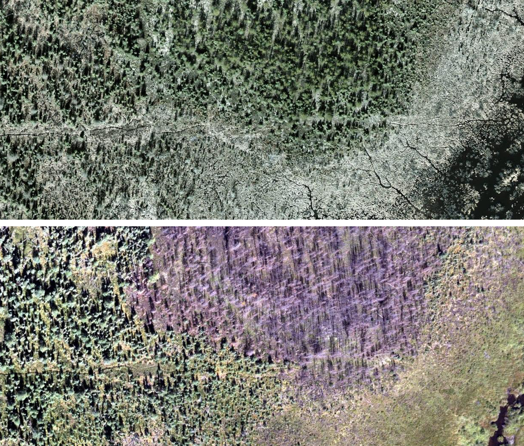
Data Tour
See how drones and deep learning can assist seismic-line restoration.

Enhanced Safety
Reducing Foot and ATV Travel in Remote Areas
Foot and ATV travel in remote areas carries serious risks, including rough terrain, wildlife encounters, and exposure to extreme heat or cold. During wildfire season, simply traveling through dry areas can spark a fire. If a wildfire starts, it can shut down all operations in the area, put people’s health at risk, and lead to major financial and environmental costs.
Using drones reduces the need for ground travel, helping to prevent these risks and keep crews safe.

Fewer Helicopter Flights, Lower Risk
Helicopters come with inherent risks, but those risks are even greater during helicopter-supported fieldwork. In these situations, even small issues can escalate fast. By using drones to collect data, we reduce the need for helicopters and avoid exposing field crews to these added risks.

Cost Efficiency
Labor and Logistics Savings
A drone team can often do in a day what a ground crew might take a week to cover. This means lower labor hours and fewer expensive site visits. For example, rapid drone spot-checks can cut inspection time by 80%, reducing the need for large field teams and travel expenses. In addition, less manual work in risky areas can reduce insurance premiums and equipment costs (fewer helicopters, trucks, etc.)
Helicopters Cost More
Drones dramatically reduce the cost of routine inspections and surveys - they don’t require expensive manned aircraft. In fact, UAV inspections might be 50-300% cheaper than helicopter inspections. Replacing a crewed helicopter flight (often thousands of dollars per hour) with a drone flight (just operational team and equipment) yields immediate savings.

Proactive Monitoring
Drones make inspections more efficient, helping to catch issues early — before they become costly problems. For example, if a leak is detected early, companies can fix it and provide proof of remediation, which may help reduce insurance premiums. Similarly, if disturbed areas extend beyond approved boundaries, early identification allows for quick corrective action, avoiding fines and costly restoration work later. By finding and addressing issues early, drones help prevent environmental damage, reduce liability, and avoid unnecessary expenses.

Long-Term Environmental Records
Precision Mapping
Aerial records provide a lasting snapshot of site conditions that can be referenced long after a flight is completed. These records serve as a baseline for environmental conditions, helping track changes over time, support future assessments, and demonstrate compliance if questions arise.
By capturing high-resolution data now, companies create valuable documentation that can be used opportunistically for new needs that may emerge in the future — from restoration planning to regulatory reviews.
Scalable Solutions
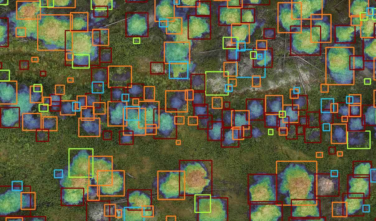
Drone data is most powerful when combined with AI and automation, as we developed in Falcon & Swift Geomatics. This combination makes it possible to assess environmental indicators almost in real time. Using AI with drones is like having a thousand people helping you map at once — turning large-scale monitoring into a practical, repeatable solution.
High-Resolution Environmental Snapshot
Drones allow us to map every feature across a site — from vegetation and water bodies to disturbed areas and infrastructure. This “environmental census” provides a complete, up-to-date picture of site conditions, helping identify issues early, prove compliance, and avoid costly surprises.